Race to the roof Survey in April to settle Bangladesh’s tallest peak debate

Deep in the mist-covered hills of Bandarban, where clouds brush against jagged ridgelines and maps still leave room for doubt, a quiet but historic mission is underway – to finally answer a question that has lingered for decades: which is the highest point in Bangladesh?
From April 4 to April 12, a specialised team from the Survey of Bangladesh is trekking through some of the country’s most remote and rugged terrain in Ruma and Thanchi upazilas, armed not with hiking gear alone, but with cutting-edge geodetic technology.
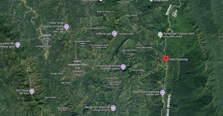
At the heart of the mission is an effort to determine, once and for all, whether Tajingdong, Keokradong or Saka Hafong stands tallest – a debate that has long intrigued geographers, trekkers and policymakers alike.
Science meets the hills
Leading the expedition is Surveyor General Brigadier General Noor-e-Alam Mohammad Jobayer Sarwar, alongside a technical team headed in the field by Deputy Director (Survey) Debashish Sarkar. Their task is far from routine.
Using advanced Global Navigation Satellite System (GNSS) receivers, Real-Time Kinematic (RTK) systems, total stations and precision level machines, the team is measuring not just elevation, but true elevation – calibrated against mean sea level (MSL) with centimetre-level accuracy.
This is where modern science steps in. A newly developed geoid model will help convert satellite-based ellipsoid heights into accurate sea-level-based measurements, aligning Bangladesh’s data with international standards.
Into the unknown
The journey itself is as demanding as the science behind it. The survey team is navigating through hard-to-reach areas – Thanchi, Remakri, Ruma, Tindu – known for steep mountain trails, river crossings and limited connectivity.
Each measurement point requires careful setup, stable positioning and hours of data collection. Weather, terrain and isolation all add layers of complexity to the mission.
Settling a long-standing debate
For years, Keokradong was widely considered the highest peak in Bangladesh, even gaining popularity among trekkers. Later, Saka Hafong emerged as a strong contender, with some claiming it surpassed all others. Tajingdong, too, has remained in the conversation.
Conflicting data, outdated measurement methods and a lack of precise geodetic surveys have kept the debate alive.
This new initiative aims to change that.
More than just a number
Officials say the significance of the survey goes beyond settling a geographical argument.
Accurate elevation data is crucial for mapping, disaster management, infrastructure planning and even climate research. In a country vulnerable to climate change, knowing the exact height of its highest peak matters more than ever.
Awaiting the final word
As the team moves from one peak to another, collecting high-precision data under challenging conditions, anticipation is building.
When the results are finally compiled, Bangladesh may not just discover its true highest peak – it will also mark a step forward in scientific mapping and national geographic identity.
Until then, the hills keep their secret, but not for long.